The Runs of Summer

After a long delay filled with nothing at all but endeavoring to train consistently and dealing with real life, here are a few photos of some of the runs I wrote about in my previous post. And yes, I will be posting more frequently now that some non-running related stresses have been removed, and that there appears to be a bit of light at the end of the tunnel to this whole Covid thing.

Dry Canyon Road

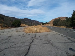
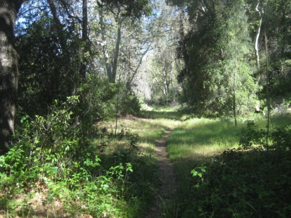
About an hour north of Ojai along Highway 33 is a lone stretch of landscape called Rancho Nuevo in the Los Padres National Forest. The road runs about 20 miles north up into a land of scrub pine and year round springs, then down into appropriately named Dry Canyon.

This area is, by far, THE most remote feeling location I’ve ever run in. Not even runs in bona fide wilderness areas feel as remote as this run, which is why I return to it as often as I can.

Manzana Trail
Manzana is Spanish for Little Apple. Apropos since this 8.5 mile trail takes you to a turn of the (previous) century school house, long since abandoned.
Manzana School house
Manzana School House

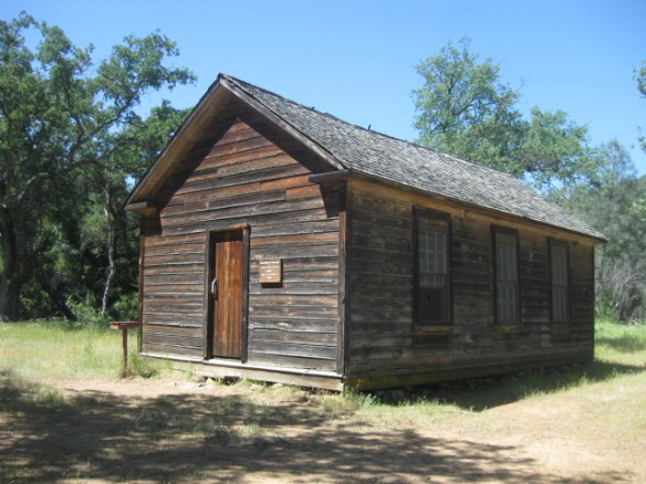
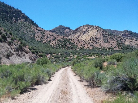
This bucolic scene is called the San Rafael Wilderness, about an hour north west of Santa Barbara. To get to this particular trailhead, you have to navigate a paved road where the word “paved” means that careless driving can remove an axle, particularly from a twenty year old low-slung Honda Civic.

The trail itself is called the Manzana Trail, and it leads about 8.5 miles from the start near Nira Campground to a turn of the (previous) century one room school house where homesteaders attempted to settle and tame the land. It didn’t work, but the upside is it’s an amazing place to spend three hours running through streams without slipping, and dodging resident horses who claim the space where a working ranch still exists by ambling up to you out of nowhere and neighing a horsy “hello.”

Whitney Trail
Did you know there is a trail that runs up to the actual Whitney Portal? There is, and I ran it.

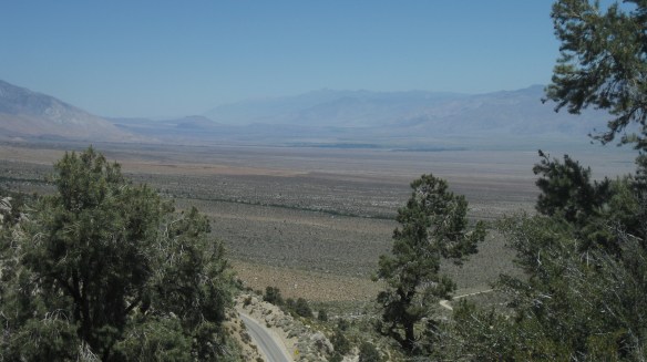
This beautiful photo of the southern Owens Valley was taken half way up three miles of living hell. You can see a portion of the Lower Whitney Portal trail on the lower right, which from that point ascends a lung busting 20% grade up to my current vantage point, a mere two and a half miles from the start, with about another mile and a half to go. The entire route ascends nearly four thousand feet in elevation over four miles. But it takes you up to Whitney Portal where they serve an awesome turkey burger. Which is perfect mid level ballast for the harrowing descent back down.

Thousand Island Lake
The Sierra Nevadas, as envisioned by Satan.
Alien Sun
Alien Sun

Through the burning hell of a forest fire I ascended. My reservation at Reds Meadow Resort and rental car too expensive to waste sitting around stewing in ash and getting angrier and more frustrated by the second, I put my lungs to the test and ascended the nine mile segment of the Pacific Crest Trail north of the Devils Post Pile National Monument up to an intersection with the John Muir Trail at Thousand Island lake. Oddly enough, the smoke seemed to dissipate once I passed 10,000 feet elevation, but that may have been the hypoxia speaking.

But seriously. The weather was clear as a bell all the way up I-395 until just south of Mammoth Lakes, when a bank of storm clouds I assumed was some sort of late season thunderstorm resolved into an ash cloud generated by the fires near Fresno and the western entrance into Yosemite National Park. I knew there was a health risk when I took off for this six hour excursion, and I should have made other plans. But I survived, and the lingering cough I caught from it dissipated after a few days. After the fact, I find myself googling terms like “lung cancer risk” and PM2.5 hazards. What’s done is done, but…

Eighteen round trip miles of Sierra awesomeness with 3,000 feet of elevation gain, but at what cost? WHAT COST?

The runs will continue. Moving through wilderness at person speed is essential to maintaining my love of running so that I can reach the goals I’ve set for myself, and most importantly, surpassing them. Because if not now, when?

See you next.

Golden State Highway

Let’s face it: the only way to get better at running hills is to, well, get off your lazy butt and run them. Hill training is a part of marathon life, and if you’re not willing to put yourself through it, why are you running, anyway?

After all, hill training offers the following benefits:

  • Improved running mechanics
  • Speed
  • Strength
  • Endurance
  • Confidence

I may be wrong. Perhaps not everyone needs to run hills to race. But if, like me, you are gunning for a Boston Marathon qualifying time, you’d better put hill running on your calendar or you will end up missing some terrific benefits.

My problem: I get bored easily when I run the same routes. Solution? Find new ones. I’ve compiled a list.

First on the list: after spending the night up at the Mt. Pinos dark sky site to rebel against the “fall back” time change and break in a new pair of binoculars, this place.

Old Hwy 99

Old Highway 99, abandoned and unmaintained, once called the Golden State Hwy, but known today as the Templin Hwy.

If you’ve ever driven up Interstate 5 on your way to anywhere north of Santa Clarita, you’ve probably passed by a stretch of California highway history without even realizing it.

The Golden State Highway. Ol’ Route 99. And much like that stretch of US 66 near Flagstaff immortalized in the original Cars movie, largely forgotten. It was the path out of Los Angeles to points north, until the Department of Water and Power decided to create Pyramid Lake and the Johnson administration finished the last of the paving on the newly christened Golden State Freeway.

But the stretch I ran today still exists. From where I parked after exiting the I-5 at the Templin Highway exit, the road ascends a perfectly engineered 5% grade for two miles before dropping three miles to a gate accessible to the Department of Water and Power that leads to the dam holding back all that water at Pyramid Lake. The gate is open to hikers and cyclists; in fact, Piru Creek, which carries the lake’s overflow, is one of those hidden fishing spots no one wants to tell outsiders about, judging from the few vehicles parked at the gate and the dearth of campers, despite the available facilities. Taken as a whole, it is a monumental fourteen mile hill run, undulating five hundred feet up its first two miles, then down close to seven hundred feet over the next three miles to the DWP gate, and finally up again through the gate to the point where a DWP access-only sign warns you against proceeding any further.

A fourteen mile round-trip sun-exposed hell-beast of a hill run, a mosaic of broken pavement that time forgot. A pitted nightmare for cars (you will slow down or you’ll find yourself airborne sans an axle at one particularly troublesome spot). And the Highway Patrol loves it because after pulling you over on the Interstate, they can drive it back up to a secret gate that opens to their speed trap hidey-hole at a brake check pull out.

At some point, I will have to conquer the entire thing, but not today. On tap was an easy four miler consisting of two miles up and two miles down. A gusting headwind made the 5% grade particularly troublesome, and my upward run turned into a series of four half mile long hill repeats. But not to worry, I will run the entire 14 mile route. Because if I can’t, there is no way I can qualify to run Boston.

More to come.

Pinos Camp

This is how I ignore the whole “Spring Forward / Fall Back” issue.